The volunteers on this Paleocultural Resource Group (PRCG) project arrived on Saturday. Students from Oklahoma State University and University of Colorado at Colorado Springs had arrived the previous Tuesday. When we, the volunteers arrived, the number of people on the project increased to 41. This many people requires major logistics for feeding, drinking, transportation, and bodily functions.
On our first day, I and two other volunteers, formed a team to map structures and sites. One of our team members had many training hours in archaeology, especially with survey and mapping sites. The other team member had many hours working with PCRG on projects. I was sort of the weak link with my experience primarily in metal detecting. With that said, our average age on the team was 75.
As the week went on, we earned the sobriquet of Grumpy Old Men.
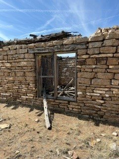
Our first project was to map a two-room schoolhouse and some associated features. We were always assigned a student to work with us so we could help them learn to map structures and sites. Our “mapper” would begin the assignment by walking around the site to determine the scale. Since the site needed to be captured on a single grid page, establishing the scale was critical. From there we would begin measuring the building.
In the schoolhouse pictures, you can see the building, while built by a husband-and-wife mason team, was a little irregular. Doors and windows were “shimmied” with rocks, board, and mud. We constantly stated out loud which points we were using to make our measurements. We also, when we could safely, measured interior walls. While it might seem simple to make a scale drawing of the schoolhouse, there were other features that needed to be captured on the single grid page.
For example, at the front door of the school house, a large timber beam had fallen down from the roof. We recorded the beam size and that beam needed to be added to the drawing. Also, there was a fence near the schoolhouse with a gate. This was very likely how students entered the schoolhouse property. Outside the fence were two posts. These posts might have been used to tie up horses. All of these items needed to be captured in the drawing. Other items added to the drawing were roof timbers. Another document created was the site description. One item noted was that the school house windows still showed a light green paint that was popular in the 1920’s. Another item was some interior walls still showed signs of lattice and plaster.
The goal of mapping the structure and site as well as writing a site description is for other archaeologists to use the data in any research they are conducting as well as, if, say in five years, an archaeologist wants to research the schoolhouse, would the map and description enable them to find and recognize the schoolhouse.
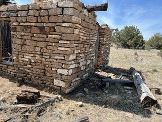
We worked on mapping more sites including a large house connected by a concrete path to a milk house connected to a granary connected to a garage. Alongside the house was a garden and water storage site. All of these sites required a lot of measuring and especially agreement on what we were measuring. The milk house was interesting as the roof, similar to the roof in the school house, was still intact. (It was very cool inside the milkhouse despite the outside heat.) Parts of the roof contained a least 12 inches (0.30 meters) of mud for insulation. We also measured the pitch of the roof.
While our “mapper” was drawing details, we “tape measurers” would be reassigned to tasks such as photographing artifacts and working with students to assign GPS locations to the artifacts.
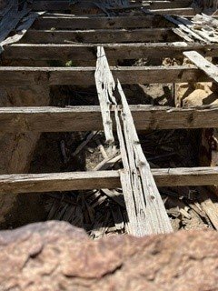
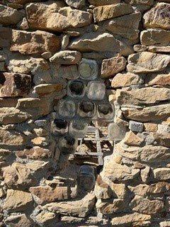
Our final map project was another house with a basement and a long narrow garage. Lots of windows and doors. We did manage to go into the basement, despite the collapsed roof, to make our measurements. In the photo, an interesting feature of the house was the owner used large glass bottles with lids to enable light to come into part of house by taking the lids off and not allowing light by putting the lids back on. (See pictures of the glass jars and the “scary” basement.)
And as a reminder of why we are avocational (amateur) archeologists, after we measured the garage, a professional archeologist showed us the owner had used large flat rocks sandwiched between larger rocks to create shelfs around the entire garage. We missed that.
As for metal detecting, I had my metal detector with me but one archaeologist said it would make no sense to use a metal detector because of the huge amounts of metal, such as nails, hinges, and so on. Given the temperature was over 100 degrees, I chose not to debate the point. I would have recommended that I search for coins as I am sure folk lost some money around the buildings. Coins are very useful for dating sites.
It was very rewarding working with Paleocultural Research Group as a volunteer. I learned much about documenting features and sites.
Note: I found a link to an article about the students from University of Colorado at Colorado Springs who participated in the project. The article is titled: Fielding cows and dust devils in southern Colorado.
And yes, there were actually two bulls we encountered: one at the front of the herd and one at the back herd. The herd crossed our path during a survey and recording of a site. The first bull would take a few steps, stare at us, and then take a few more steps, stare again at us. Grabbing the bull by the horn was not an option. After awhile, the bull decided we were not a threat and the herd moved on. (This happened last year at another project in Vogel Canyon located in Colorado. In that instance, the bull snorted a bunch of times, probably a bad sign.)
Here is the link: https://communique.uccs.edu/?p=157068